Thursday, July 28, 2011

Side trips: other places we saw on the Tour


     We tried three times to get down into Sheep Falls on the Falls River.  First we were stopped by snow on the road, next we were stopped by mud and the third time we were stopped by a steep rocky drop that I thought might be too much for the old Jeep.   Without another rescue vehicle along and no winch to help us climb back out we decided not to take the risk.   We're going back next year with at least two Jeeps.  Any volunteers?


     The long muddy hole that stopped us from getting down into Sheep Falls on the second try.


Here's a pic of Sheep Falls on the Falls River I found on the internet.


     Robinson Creek.  We crossed here a number of times during the Tour to get to or from the places we visited.  In the winter, this bridge gets us to some outstanding snowmobiling areas.


     We helped unload some cows onto summer pasture along Conant Creek.


     The Tetons as seen over the railing at the corral.


      Our Little Wrangler giving instructions to the cows.


     We saw many old buildings from the early days of settlement in this area.  The hard working people who developed this area must have been some hearty folks!


     An old building in the town of Drummond.


     We fed two young horses being kept in a separate corral from the rest of the herd. 


     Horseshoe Lake along the western boundary of YNP.  We didn't get to spend as much time here as we would have liked.  Definitely going back next year.


Johnny Sack Cabin at Big Springs in Island Park.  Stopped here on our way to lunch at the Old Faithful Inn.


Wednesday, July 27, 2011

Warm River Butte: former fire lookout site

     The lookout tower is no longer there, but the view from the top of Warm River Butte is still awesome.  The entire Teton Mountain range, the high plateaus of Yellowstone National Park and much of the Targhee National Forest are visible from up there.  Warm River Butte is along the Fish Creek Road.


     The Tetons in the distance still have snow on them while the flowers bloom on Warm River Butte.


     Moose Butte in the foreground and the plateaus of YNP along the horizon.


     The Targhee National Forest below Warm River Butte.


     All that remains of the lookout tower are some cement footings and jagged steel.  These towers are a significant part of the history of our national forests.  It's unfortunate that more of them haven't been preserved.


     Going back down the narrow, winding and sometimes steep road on Warm River Butte.  Travel in low clearance vehicles isn't recommended.  You might make it, but you might lose a part or two along the way.

 Near Warm River Butte last winter.

    It's still called the Targhee National Forest, or, just the Targhee, by locals. But it's official name became the Caribou-Targhee National Forest a number of years ago after management of the two Forests was merged.  Here's a link to the Forest's home page:  http://www.fs.usda.gov/wps/portal/fsinternet/!ut/p/c5/04_SB8K8xLLM9MSSzPy8xBz9CP0os3gjAwhwtDDw9_AI8zPwhQoY6IeDdGCqCPOBqwDLG-AAjgb6fh75uan6BdnZaY6OiooA1tkqlQ!!/dl3/d3/L2dJQSEvUUt3QS9ZQnZ3LzZfMjAwMDAwMDBBODBPSEhWTjBNMDAwMDAwMDA!/?ss=110415&navtype=BROWSEBYSUBJECT&cid=FSE_003853&navid=091000000000000&pnavid=null&position=BROWSEBYSUBJECT&ttype=main&pname=Caribou-Targhee%20National%20Forest-%20Home/

Tuesday, July 26, 2011

Lunch at the Old Faithful Inn

    We took time out from our Jeep travels to take a day trip to Old Faithful and have lunch with my mother at the Old Faithful Inn while she was visiting from Pennsylvania.


     The drive up to the Inn.


     The dining room at the Inn.  We just barely beat the crowd.  Shortly after this picture was taken every table was full.  The buffet, which we enjoyed, included Bison chili and pan fried trout.


     Looking up from the center of the lobby.  This is a small section of the log structure of the Inn. You really have to stand there and see it in person to get the full sense of this building.  Don't miss it on your YNP trip.

     Here's a link to the Yellowstone National Park site which contains information on the history and construction of the Old Faithful Inn, and other information on the area around Old Faithful.

Monday, July 25, 2011

Cascade Corner: Cave Falls and the Bechler Ranger Station

     If I were told that I could only visit one section of Yellowstone National Park for the rest of my life, this would be it. No question.  No hesitation.  End of discussion.

        We think of YNP as two separate places.  There's the "Front Country", the places that most visitors see. Places like Old Faithful, Grand Canyon of the Yellowstone, and Yellowstone Lake.  Then there's the "Back Country".  Those more remote places that fewer visitors get to enjoy.

     The Cascade Corner is one of those remote places. Named for all of the waterfalls on the Bechler and Falls Rivers, it is located in the southwest corner of the Park.  There are no paved roads to lead you there.  To get to the Cave Falls and Bechler River section you'll drive the 15 mile dirt road called the Cave Falls Road east of Ashton or take the 30 mile hike from Old Faithful.  To get to the Falls River section you'll drive the dirt road called the Reclamation Road, also known as the Flagg Ranch or Grassy Lake Road, east of Ashton, or, again, hike in from other areas of the Park.  I'll give you info on the area accessed  from the Reclamation Road in a future post.


     If you see a YNP entrance sign next to a dirt road, you can be pretty sure you're entering the back country.


     This way to the Bechler Ranger Station, that way to Cave Falls.


     Cave Falls.  Not the best picture we've ever taken, but its the one we have from the Summer Tour.  Google "Cave Falls" to see better pics.  Cave Falls is a product of the water of the Bechler and Falls Rivers, which join a short distance upriver from here.

     Its called Cave Falls because of the large cave next to the falls, to the left in this pic.  In the past visitors could hike up the edge of the river and stand inside the cave to admire the falls.  Unfortunately, the cave roof collapsed a few years ago and the cave is now unsafe to be in and is closed off.


     Hiking down to the Cave Falls Overlook.

     Looking down the Falls River from the Cave Falls Overlook.

     Enlarge the picture and read the story of the Bechler Ranger Station.  We recently learned that my wife's grandfather was a soldier stationed in YNP during the time this building was built.  We're attempting to locate his service records to see if he played a role in the construction of the Station.


   A trail sign near the Bechler Ranger Station.  There are a number of day hikes available from the Station.  Don't forget your mosquito repellent and your bear spray.  You'll need both.

     The Idaho PBS station did a terrific special on the Cascade Corner.  You can order it from their website.  Here's a link to the online version of the show.  Definitely worth taking the time to watch.  Two of the folks in the video are friends of ours.  Bechler Ranger Dave Ross and horse packing guide Brad Rhodes.  Remember to click the full screen button in the lower right hand corner for the best viewing.

http://video.idahoptv.org/video/1476047808


     Bechler, our dog.

Sunday, July 24, 2011

The Jackass Loop

     Yup, that's what it's called.  I can't tell you with certainty why it's called that. But one story we've heard is that a herder in the area years ago named Jackass Meadows after his jackass. Jackass Loop goes through Jackass Meadows.

     If you look around the west you'll find many places with the name jackass in it.  Mr. Jackass really got around!

     And, like many of the other places with that colorful name, the name does not do it justice.

     A ride on the Jackass Loop gives you as good of a tour through this amazing country as you'll get. It begins and ends on the Reclamation Road east of Ashton.  It circles the area known as Squirrel Meadows. It crosses a number of creeks and drainages including Squirrel Creek, Dry Creek, Jackass Creek, Jackass Meadows and South Boone Creek.  It starts in Idaho and ends in Wyoming.  It travels along the border of the Jedediah Smith Wilderness Area and provides access for those who wish to hike or ride horseback there.  And it makes a nice side trip on the way to or from the Cascade Creek trailhead along the southern boundary of YNP, Grassy Lake and Flagg Ranch on the Reclamation Road.

     And, like many of the places you'll visit around here, the mosquitoes can be thick.  So, leave the so-called-skin-product-as-mosquito-repellent home.  DEET is the word.  Apply liberally.  For those allergic to DEET, there's another ingredient, Picaridin, used in some products. It is almost as effective as DEET.

     We've made several trips on the Jackass Loop already this summer and are looking forward to more before the season ends.  Then, from about Thanksgiving until Easter, we'll ride it on snowmobiles.


     Dry Creek at the west end of the Loop.


     Another pic of Dry Creek farther up the meadow.


     A short side trip off of the Jackass Loop, down over Conant Creek, will take you to the Coyote Meadows Road, another access point to the wilderness area.


     Ernst Lake is a great place for a lunch stop.  Just remember:  DEET!

     (Close your eyes, picture jagged snowcapped peaks here)

     The Tetons are up close and spectacular along the Jackass Loop.  Unfortunately, we had the camera set incorrectly and all the pictures we took were washed out.  So, you'll just have to go see for yourself.


     How bad can the mosquitoes be?  Well, I'll tell you.  On one of our trips we had my dear 81 year old mother along (in the Explorer).  We stopped at this hitching post in a hunting camp along the border of the Jedediah Smith Wilderness Area and posed her in front of it for a picture.  Before I could take the picture, the mosquitoes lifted her up and carried her away.  Fortunately, the wind was down slope.  She landed safely in Squirrel Meadows.


     South Boone Creek trailhead.


     South Boone Creek fast and full from snowmelt off the Tetons.


     Remember this guy?  Jackass Loop.  The area around Squirrel Meadows has a significant population of grizzlies.  So, if you go there, learn how to travel safely in bear country before you go.

Saturday, July 23, 2011

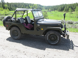
Up close: our 1953 Willys M38A1


     My dad was in the Big Red One in World War II.  He was awarded the Purple Heart for wounds he received in battle while fighting in the Ardennes Region just three weeks before the start of the Battle of the Bulge.


     When you travel around in a 58 year old Jeep, there's always the possiblity of a break down.  We carry basic tools and spare parts, plus all the supplies we'll need to stay out for a few days if we can't get it fixed.


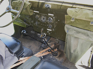
     Surplus store canvas bags give us additional storage.  Small white label on upper left of instrument panel says "Cornering speed 15", the one on the right says "Max speed 45".  Note the very basic anti-theft device. Putting the gear shift lever in reverse puts it next to the heavy steel ring attached to dash, then just lock the pad lock around the lever.  Small round ring hanging off bottom of dash goes over short lever when in low range, keeps it from popping out of gear when going over bumps, etc.


     The white sticker over the round black button says "Bear Horn".  We blow it as we move through the timber to let them know we're in the area.


     Do you know the story behind this WWII drawing?  Google it.


     The new chainsaw and gun rack, with cup holders!

     Want to know more about the M38A1?  Here's a link:  http://www.m38a1.com/

     Want to join a forum on the Willys M Military Jeeps?  Great people and great info here:
http://willysmjeeps.com/v2/

The Chainsaw Search

     My wife said, "we need a chain saw" after we had to turn around because of a downed tree across the road and go back past the grizzly a second time.  Who am I to argue with that?

     I was all set to buy a shiny new one when I got thinking about older saws.  Why not have an old chainsaw for the old Jeep?  I did some reading and found that Homelite made some excellent saws back in the 60's and 70's. And, they made a lot of them.  Within a week I had bought two saws from two separate estate sales.


     The blue one is a 1972 Homelite XL-12 with a 16" bar.  The red one is a 1979 Homelite Super XL AO with a 20" bar. I've cut with both of them. They run well and are a good addition to the equipment we carry.

     Then the shop owner of Sutton's Saw Shop in Ashton told me that he had an old Homelite saw in his storage area.  It turned out to be a 1974 Homelite 150 Automatic in like new condition.


     I bought it to carry in my wife's 1963 Jeep CJ-5.  But, the saw is in such amazing condition I'd hate to ding it up, so I doubt we ever use it much.

     And so, within less than two weeks, we bought three good used saws for about half the price of one new saw.

Friday, July 22, 2011

The A1 Meets a Grizzly Bear


    Seeing a grizzly in the wild is a pretty cool sight.  Seeing one standing up on its hind legs and looking straight at you from 40 yards away while you're sitting in an open Jeep adds a bit more excitement to the whole thing!

     I have to give credit to my wife here.  In spite of being more than a little spooked, she kept snapping pictures and got some great ones for us.

     We were climbing up out of a small creek drainage, came around a corner, and there he was.  Up on his hind legs, sniffing the air and looking at us.  He dropped down after a few seconds and slowly ambled up the road and away from us.

     Fortunately, whatever he was eating in that meadow was a lot more interesting to him than us.  We sat there for at least 10 minutes and watched him dig and eat.  


     This is about where the Jeep was when we first saw him.  He was standing on the small hill you can see through the passenger side windshield.  Here he's across the meadow, probably 150 yards away. 


     There were apparently great things to eat here.  Just before we took this picture he was lying on his stomach digging under the bush behind him.

     He eventually moved far enough away from the road so that we could safely pass.  We drove about a mile and were stopped by a tree blocking the road.  We drove back and he was right back along the side of the road.  A pickup came along, we asked him to push the bear off the road for us, which he did, and we were able to drive by.

     You always hear it said that grizzlies are fast runners.  Believe it!  When the pickup pushed him off the road he took off into the timber.  Not only was he moving very quickly as he ran through the trees, he was dodging them like the best running back you've ever seen.

     We showed these pictures to some folks who know grizzlies.  The consensus was that this is a young male, maybe 2-3 years old.

     A few miles down the road after passing the bear for the second time, my wife said, referring to the downed tree that caused us to have to go back, "we need a chain saw".

     Want to know more about grizzlies?  Here's a link to the U.S. Fish and Wildlife Site on Grizzly Recovery.

http://www.fws.gov/mountain-prairie/species/mammals/grizzly/yellowstone.htm

     In the next post I'll tell you about our search for a saw and what we finally ended up with.  And I'll give you a close up tour of the Jeep we're travelling in and tell you a little about it.